Every project begins with a vision – an airport expansion, a safer roadway, a mixed-use development that reshapes a community. But before vision becomes reality, one question must be answered: what lies beneath the ground?
Buried infrastructure forms the unseen lifeline of our modern world. Water and wastewater pipes, fiber optic cables, storm drains, power lines, and natural gas networks are woven into a dense, hidden network that keeps our communities functioning. Each is essential. Each is vulnerable. And each poses risks that, if misunderstood or overlooked, can unravel even the most carefully planned project, often threatening safety, schedules, and budgets.
For decades, projects stumbled over these risks. Outdated records, incomplete as-builts, and unseen conflicts led to costly redesigns, unexpected delays, and dangerous strikes. Subsurface Utility Engineering (SUE) emerged as a proven solution to mitigate these risks. By applying cutting-edge geophysical prospecting tools, advanced data modeling, and non-destructive excavation methods, SUE provides accurate, actionable intelligence on underground conditions before shovels hit the ground.
At WGI, we’ve taken SUE further. By combining proven methodology with cutting-edge technology and an unwavering commitment to safety, we empower clients to move forward with clarity and confidence. For us, SUE is not simply about finding utilities; it’s about unlocking savings, enhancing safety, and accelerating delivery – it’s about turning uncertainty into opportunity.
A Comprehensive Suite of SUE Services
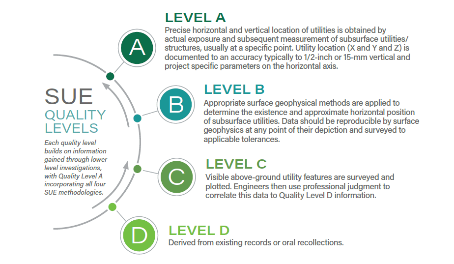
True SUE is not a single service, but an integrated framework. Guided by ASCE 38-22 standards, WGI provides utility data collection, verification, and modeling services, ensuring reliable information across Quality Levels A through D:
Vacuum Excavation (QLA): Safely exposing utilities with non-destructive air/water vacuum excavation to determine size, material, condition, and depth.
Visual Confirmation from Above Ground (QLC): Combining QLD as-builts with collected surface features to have a better estimate of locations of buried utilities.
Desktop Research (QLD): The ability to “walk” the streets on Google Earth/Maps. The Triple Cs of initial connection, communication, and coordination with Utility Owners via 811 One Call submittal for as-builts and early planning stages.
Utility Designation (QLB): Mapping the horizontal position of subsurface utilities using electromagnetic locating, 3D ground-penetrating radar (GPR), and advanced detection methods.
Utility Records Research: Collecting and analyzing existing as-built data, utility owner records, and One Call responses.
811 Damage Prevention and Coordination: Acting as a liaison between project teams, utility owners, and public agencies to prevent conflicts.
Ground-Penetrating Radar (GPR): Including high-speed, multichannel 3D GPR (MCGPR) capable of collecting georeferenced utility data at roadway speeds.
Interior and Concrete Radar Mapping: Non-invasive scanning of walls, slabs, and structures to identify embedded utilities.
3D Modeling and Augmented Reality Visualization: Integrating field data into intelligent 3D models for clash detection and design coordination.
Sub-Aqueous Utility Locating: Specialized hydrographic and sonar systems for identifying utilities under waterways.
Aerial and Mobile Mapping: Deploying lidar, aerial imaging, and drone-based systems to pair subsurface data with accurate surface conditions.
Utility Coordination: Our team brings the specialized knowledge and proven experience necessary to ensure the success of your next utility project – from planning and coordination to seamless execution.
This comprehensive suite of services equips WGI to anticipate and resolve utility conflicts across projects of any scale, from interstate highway corridors and airports to private development and energy transmission.
Leader in Innovation Solutions
The discipline of SUE has evolved dramatically. Where engineers once relied on paper maps and hand-marked surveys, today’s work leverages sophisticated hardware and software that accelerate collection, improve precision, and enhance safety, with WGI positioned at the forefront of this transformation.
Advanced Equipment Fleet
Our toolbox includes electromagnetic locators, such as the Vivax vLoc3-Pro and GPR systems, including the Raptor High-Speed 3D array, as well as a fleet of vacuum excavation trucks, including the RAMVAC AX-4000 and VacMaster 4000 series. For broader mapping applications, we operate Leica and Riegl mobile lidar systems, multi-spectral aerial cameras, and hydrographic sonar platforms.
This unmatched portfolio allows WGI to tailor our approach to each project, capturing comprehensive data in complex environments. Whether collecting MCGPR at posted roadway speeds or conducting 182 vacuum excavation test holes in a utility-dense corridor, our team has the resources to deliver.
Augmented Reality With vSite
Traditional methods, such as paper maps, 2D plans, and site sketches, often fall short of effectively communicating the true complexity of underground utilities. WGI integrates vSite, an augmented reality (AR) tool, to bring 3D models into the field.
By equipping crews with AR visualization, we reduce complexity, accelerate task execution, and minimize risk. Crews can “see” subsurface utilities in real-time, avoid conflicts, and close trenches faster, reducing public disruption and liability. The integration of vSite with Esri ArcGIS ensures seamless data exchange and instant client deliverables.
Data Integration and Smart Cities
WGI is also exploring the next frontier: pairing SUE data with artificial intelligence and smart city infrastructure. Automated clash detection, predictive modeling of utility risks, and integration with digital twins are just a few
innovations on the horizon, with the potential to reduce risk further while supporting the resilience of future urban systems.
For clients, this means a SUE process that is no longer reactive, but rather a proactive tool for shaping smarter, safer, and more sustainable communities.
The Safety Imperative
At WGI, safety is not a checkbox; it’s the foundation of every SUE operation. Our technology-first approach minimizes human error, reduces site exposure, and ensures compliance with stringent safety protocols.
By deploying MCGPR at roadway speeds, we collect massive volumes of underground data without prolonged lane closures or unnecessary worker exposure. When excavation is required, our vacuum systems eliminate the risk
of damaging utilities with mechanical digging.
This safety focus extends to the public. Whether operating in a congested airport terminal or a pedestrian-heavy downtown corridor, WGI designs work zones that protect crews, clients, and the communities they serve.
The Economics of Certainty
A Federal Highway Administration (FHWA) study found that for every dollar invested in SUE, project owners save $4.62 in avoided delays, damages, and redesigns. In fact, of 71 WGI projects deploying SUE services, 69 of them experienced cost savings. Yet this figure only scratches the surface of SUE’s actual value.
While the financial savings are real — avoided delays, fewer change orders, and reduced right-of-way rental fees — qualitative savings, such as protecting reputations, maintaining public trust, and preserving safety, may be even greater.
For developers, accurate SUE data shortens entitlement timelines and prevents costly redesigns in urban infill projects. For DOTs and municipalities, it safeguards taxpayer dollars and ensures projects advance without public backlash. For contractors, it means predictable schedules and fewer conflicts, thus positioning SUE as more than a cost, but rather an investment in certainty.
Case Studies: WGI in Action
SR 540 Drainage and Safety Improvements
On a critical 2.9-mile east-west corridor in Polk County, WGI delivered a Quality Level B utility investigation in support of drainage replacement and resurfacing.
Leveraging the Raptor High-Speed 3D GPR system, WGI collected underground data at roadway speed, minimizing traffic disruptions and quickly capturing the locations of utilities and valves buried beneath asphalt.
Follow-up vacuum excavation confirmed potential conflicts, enabling FDOT to design around existing utilities and advance its Vision Zero safety initiative without delay.
Case Studies: WGI in Action
District-Wide SUE Services for IDOT
WGI delivered 52 task work orders under IDOT’s district-wide contract, including the first Quality Level B 3D utility model deliverables in Cook County. These projects included a SUE study along 16 miles of I-80 – a major transportation corridor critical to both freight and commuter traffic.
By integrating 3D utility modeling with electromagnetic detection and vacuum excavation, WGI provided IDOT with unprecedented visibility into subsurface conditions, enabling better design coordination and reduced field conflicts.
Expertise with Vision
WGI’s SUE team combines the deep experience of industry veterans with the fresh perspective of emerging professionals. Our culture of mentorship and collaboration ensures knowledge is passed forward, while new technologies and approaches are continuously tested and adopted.
As an award-winning firm with a nationwide footprint, WGI brings consistency, scalability, and innovation to clients from coast to coast. We serve private developers, municipalities, DOTs, airports, and energy providers with equal dedication, tailoring our solutions to the unique challenges of each sector.
We also extend our commitment beyond client work, supporting non-profits, professional organizations, and local communities through volunteerism and leadership. This balance of technical excellence and civic responsibility strengthens the value we deliver every day.
The Road Ahead
The demand on infrastructure is growing. Cities are densifying, underground corridors are more congested than ever, and aging utility systems present new challenges. The need for accurate, forward-looking subsurface intelligence has never been greater.
WGI sees the future of SUE as integral to the broader vision of smart and connected communities. By integrating utility data into digital twins, leveraging AI for predictive analysis, and continually refining tools like AR visualization, we are preparing for an era where underground systems are as transparent and manageable as those above ground. This transforms the discipline from a risk-avoidance measure into a proactive design tool.
By investing in technology and people today, WGI ensures that we’re prepared to deliver the possibilities and solutions of tomorrow. This approach keeps clients ahead of challenges and at the forefront of innovation as we design more efficiently, construct more safely, and manage infrastructure more sustainably.
The WGI Advantage
Every project begins with a level of uncertainty. SUE transforms that uncertainty into clarity.
Infrastructure success depends on precision of schedule, budget, and what lies below the surface. WGI’s SUE services deliver clarity, backed by cutting-edge technology, proven expertise, and a commitment to safety and savings.
From interstate highways and airports to urban infill developments and energy infrastructure, WGI provides the intelligence that makes projects possible. Our clients see the difference not just in avoided conflicts and reduced costs, but in projects that move forward with greater accuracy and confidence.
When the stakes are high and the unknowns are many, WGI is the partner that helps you see what lies below – so that you can build what comes next.
Let's Talk.
For more information about this paper or to have a conversation with one of our experts, please contact:
.png?width=185&height=175&name=WGI%20Icon_Green%20(1).png)